Creating Design Guidelines for a New City:
Sejong, South Korea
By Maritza E. Mercado and Sarah K. Peck
(Originally published in The New Planner — Spring 2008)
Seoul, the capital of South Korea, is a dynamic, energetic city. Known as "the world's largest company town — a gemeinshaft of hypercapitalism," it is the economic heart of a country that boasts the third largest economy in Asia and the 12th largest in the world. With a metropolitan area of 10.4 million people (roughly 20 percent of South Korea's population), Seoul is also a city plagued by overcrowding, congestion, housing shortages, and pollution.
In 2002, responding to these pressures on Seoul, South Korean president Roh Moo-Hyun proposed the creation of Sejong as the country's new capital. The nation's supreme court, however, found the plan unconstitutional and rejected the proposal. Yet planning and development for the new city continued, with the stipulation that only the administrative functions of the government would be moved to Sejong.
Described as a "Multifunctional Administrative City (MAC)," Sejong would be a "world-wide model city where everyone desires to live," a center that would incorporate elements of happiness, health, and equality through innovative planning and design. Planned for an 18,000-acre site roughly 100 miles south of Seoul, Sejong is expected to be a completely self-sufficient model city with a population of 500,000 by 2030.
Sejong's Master Plan
In 2005, a competition for the master plan for Sejong (MAC) was held and five winning designs were chosen. The competition jury selected the five top submissions, and today's master plan for Sejong is an amalgamation of the five winning designs.
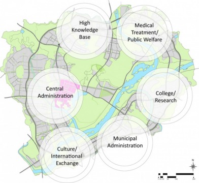
Within Sejong, there are to be six sub-centers situated in a roughly circular ring form, featuring a central open space in the center of the ring. The idea behind the town's layout is that all Sejong citizens will have easy access to open green space. One of the sub-centers would be the Public Administration Town (PAT).
The PAT is projected to house approximately 25,000 residents and provide office space for 14,000 central government employees from 49 ministries and four institutes. In 2007, Haeahn Architects and Balmori Associates won the design competition for the PAT.
To see the winning competition entry, go to www.balmori.com.
Flat-Link-Zero: The Winning Competition Scheme
The core principles of the winning design for the PAT are ecological sustainability, spatial and conceptual equality, a flattening of the skyline, and the integration and connection of the city to the region, nation, and world. These ideas are conceptually represented as Flat, Link, and Zero City.
The idea of a "flat" city is captured in the iconic design of a government building wrapped throughout the city and elevated on pilotis, or piers. In a country known for its high-rise residential towers and downtown density, the winning scheme proposed height restrictions in the center of the PAT to create a continuous landscape plane that connected people from the tops of buildings to the ground plane.
To create a "link" city, circulation, land use and public space systems were analyzed in three dimensions. Vehicles and pedestrians, street sections and transit plans, and vertical circulation are key to understanding the logistics of the complex design.
The "zero" city design suggests that the entire city become sustainable. Issues of water management, energy efficiency, recycling, food production, and waste management are addressed in the city's design guidelines.
In 2005, a competition for the master plan for Sejong (MAC) was held and five winning designs were chosen. The competition jury selected the five top submissions, and today's master plan for Sejong is an amalgamation of the five winning designs.
Within Sejong, there are to be six sub-centers situated in a roughly circular ring form, featuring a central open space in the center of the ring. The idea behind the town's layout is that all Sejong citizens will have easy access to open green space. One of the sub-centers would be the Public Administration Town (PAT).
The PAT is projected to house approximately 25,000 residents and provide office space for 14,000 central government employees from 49 ministries and four institutes. In 2007, Haeahn Architects and Balmori Associates won the design competition for the PAT.
To see the winning competition entry, go to www.balmori.com.
Flat-Link-Zero: The Winning Competition Scheme
The core principles of the winning design for the PAT are ecological sustainability, spatial and conceptual equality, a flattening of the skyline, and the integration and connection of the city to the region, nation, and world. These ideas are conceptually represented as Flat, Link, and Zero City.
The idea of a "flat" city is captured in the iconic design of a government building wrapped throughout the city and elevated on pilotis, or piers. In a country known for its high-rise residential towers and downtown density, the winning scheme proposed height restrictions in the center of the PAT to create a continuous landscape plane that connected people from the tops of buildings to the ground plane.
To create a "link" city, circulation, land use and public space systems were analyzed in three dimensions. Vehicles and pedestrians, street sections and transit plans, and vertical circulation are key to understanding the logistics of the complex design.
The "zero" city design suggests that the entire city become sustainable. Issues of water management, energy efficiency, recycling, food production, and waste management are addressed in the city's design guidelines.
Design Guidelines: Reinforcing the Integrity of the Competition Entry
In 2007, 12 students in a collaborative architecture, city planning, and landscape architecture studio at PennDesign (the School of Design at the University of Pennsylvania) were asked to create design guidelines for the PAT winning competition entry. The team's mission was to begin to understand how to translate a winning design competition into guidelines that address development, construction, and building regulations.
Akin to zoning regulations, most design guidelines typically create restrictions that reference a plan in two dimensions. As noted in the studio syllabus, "most urban design guidelines are conceived in plan, as a series of parcels, with set-backs and coverage restrictions, the studio will have to invent new ways of describing and encoding design." The project required a new approach in order to address the complex three-dimensional geometry of the competition design.
The team sought to implement these ideals at every level of the city's operation. The question of how equality, connectivity, and sustainability could be expressed at the scale of urban systems, local districts, and individual buildings presented a complex design problem: What does "equality" mean for a transportation system? How does sustainability operate across the whole city and within an individual building?
These investigations culminated in a framework of realizable goals and specific guidelines that will allow the government and people of South Korea to achieve the aspirations set forth in the winning design. "Design Guidelines for the PAT of the MAC: Sejong, Korea," published in February 2008, documents different explorations that created the framework for a set of design guidelines for the Korean government.
For example, chapters two and three, "Regional Connectivity" and "Structuring Multi-Modal Transportation," address the need for direct high-speed rail connections from Seoul to southern cities, examine parking demands, prohibit structured parking in the central area to reduce traffic and auto emissions, and call for local pedestrian-only streets and connections between the PAT and the rest of Sejong through bus rapid transit and commuter bus systems.
The design guidelines also address mixed-use development, the creation of both an iconic plane and an iconic edge to implement the structural concept of the government building and landscape plane, the issue of open space within the PAT, sustainability within buildings, residential urban form surrounding the PAT, and ecological efficiency, including topics such as intensive urban agriculture, green roofs, gray water separation, photovoltaics, storm water swales, and water management.
Creating design guidelines in 12 weeks was challenging — and the implementation and the effectiveness of the guidelines remains to be seen. The government broke ground on the project within one year of announcing the winning competition entry. Because construction is already underway, it may be difficult to maintain the integrity of the winning design.
Challenges for Moving Ahead
The site for Sejong is the Jangnam Plain, which contains acres of rice paddies as well as several small villages.
As some observers have noted, the South Korean government is bold to suggest creating a new city — and displacing villagers — in this pristine landscape. Are the density problems so grave in Seoul that they can't be solved without creating a new place? In September 2007, during the PennDesign studio team's visit to the Korean Land Corporation's office at the future site for Sejong, a group of loud protesters was camped out at the entrance. The team was told that the group had been there for weeks protesting the displacement of citizens to make way for the new city.
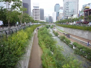
In December 2007, South Korea elected a new president, Lee Myung-bak. Lee had been the mayor of Seoul and in that position led several large-scale urban projects, such as the restoration of the Cheonggyecheon stream, a project that daylighted a large stream running under Seoul.
As mayor, Lee was a big opponent of the Sejong project. In his capacity as president, it is unclear whether he will support the project. Opponents of the Sejong project cite its distance from Seoul and displacement of the existing population as major concerns. Additionally, as South Korea has not experienced significant population growth, some speculate that Sejong would not attract enough residents to sustain itself.
This is not the first time South Korea has proposed a new city. Construction of Songdo, a new city near Seoul's international airport, began in 2002. Songdo's master plan, created by American architects Kohn Penderson Fox, calls for development on 1,500 acres of reclaimed coastal land. Will Sejong follow in Songdo's footsteps or will President Lee stop the project in its tracks?
To view the Songdo master plan, visit www.kpf.com.
If Sejong is ultimately built out as planned, only time will tell if the design guidelines will uphold and enhance the winning competition scheme for the PAT. Design guidelines, when done well, can create a set of rules that allow flexibility of design and occupation over time, while also setting the stage for an interaction between developments that promote contiguity across space.
The studio that this article is based on was led by Professor Jonathan Barnett. The student participants were Carrie Bergey, Lisa Beyer, Michael Burlando, Stacey Chen, Joseph Hang, Nathan Katz, Rafaela Kirloss, Douglas Meehan, Maritza Mercado, Josiah Neiderbach, Andrea Ioana Pantor, and Sarah Peck.
In 2007, 12 students in a collaborative architecture, city planning, and landscape architecture studio at PennDesign (the School of Design at the University of Pennsylvania) were asked to create design guidelines for the PAT winning competition entry. The team's mission was to begin to understand how to translate a winning design competition into guidelines that address development, construction, and building regulations.
Akin to zoning regulations, most design guidelines typically create restrictions that reference a plan in two dimensions. As noted in the studio syllabus, "most urban design guidelines are conceived in plan, as a series of parcels, with set-backs and coverage restrictions, the studio will have to invent new ways of describing and encoding design." The project required a new approach in order to address the complex three-dimensional geometry of the competition design.
The team sought to implement these ideals at every level of the city's operation. The question of how equality, connectivity, and sustainability could be expressed at the scale of urban systems, local districts, and individual buildings presented a complex design problem: What does "equality" mean for a transportation system? How does sustainability operate across the whole city and within an individual building?
These investigations culminated in a framework of realizable goals and specific guidelines that will allow the government and people of South Korea to achieve the aspirations set forth in the winning design. "Design Guidelines for the PAT of the MAC: Sejong, Korea," published in February 2008, documents different explorations that created the framework for a set of design guidelines for the Korean government.
For example, chapters two and three, "Regional Connectivity" and "Structuring Multi-Modal Transportation," address the need for direct high-speed rail connections from Seoul to southern cities, examine parking demands, prohibit structured parking in the central area to reduce traffic and auto emissions, and call for local pedestrian-only streets and connections between the PAT and the rest of Sejong through bus rapid transit and commuter bus systems.
The design guidelines also address mixed-use development, the creation of both an iconic plane and an iconic edge to implement the structural concept of the government building and landscape plane, the issue of open space within the PAT, sustainability within buildings, residential urban form surrounding the PAT, and ecological efficiency, including topics such as intensive urban agriculture, green roofs, gray water separation, photovoltaics, storm water swales, and water management.
Creating design guidelines in 12 weeks was challenging — and the implementation and the effectiveness of the guidelines remains to be seen. The government broke ground on the project within one year of announcing the winning competition entry. Because construction is already underway, it may be difficult to maintain the integrity of the winning design.
Challenges for Moving Ahead
The site for Sejong is the Jangnam Plain, which contains acres of rice paddies as well as several small villages.
As some observers have noted, the South Korean government is bold to suggest creating a new city — and displacing villagers — in this pristine landscape. Are the density problems so grave in Seoul that they can't be solved without creating a new place? In September 2007, during the PennDesign studio team's visit to the Korean Land Corporation's office at the future site for Sejong, a group of loud protesters was camped out at the entrance. The team was told that the group had been there for weeks protesting the displacement of citizens to make way for the new city.
In December 2007, South Korea elected a new president, Lee Myung-bak. Lee had been the mayor of Seoul and in that position led several large-scale urban projects, such as the restoration of the Cheonggyecheon stream, a project that daylighted a large stream running under Seoul.
As mayor, Lee was a big opponent of the Sejong project. In his capacity as president, it is unclear whether he will support the project. Opponents of the Sejong project cite its distance from Seoul and displacement of the existing population as major concerns. Additionally, as South Korea has not experienced significant population growth, some speculate that Sejong would not attract enough residents to sustain itself.
This is not the first time South Korea has proposed a new city. Construction of Songdo, a new city near Seoul's international airport, began in 2002. Songdo's master plan, created by American architects Kohn Penderson Fox, calls for development on 1,500 acres of reclaimed coastal land. Will Sejong follow in Songdo's footsteps or will President Lee stop the project in its tracks?
To view the Songdo master plan, visit www.kpf.com.
If Sejong is ultimately built out as planned, only time will tell if the design guidelines will uphold and enhance the winning competition scheme for the PAT. Design guidelines, when done well, can create a set of rules that allow flexibility of design and occupation over time, while also setting the stage for an interaction between developments that promote contiguity across space.
The studio that this article is based on was led by Professor Jonathan Barnett. The student participants were Carrie Bergey, Lisa Beyer, Michael Burlando, Stacey Chen, Joseph Hang, Nathan Katz, Rafaela Kirloss, Douglas Meehan, Maritza Mercado, Josiah Neiderbach, Andrea Ioana Pantor, and Sarah Peck.
